Extreme Fire Weather On The Front Range Tomorrow
The Rundown
Storm chaser eyes will be on the Plains tomorrow, but there’s a higher threat of severe weather behind the dryline.
I’m talking about fire weather. It is not something we worry about in the humid east but is the most frightening weather they get out west. An SPC forecaster recently noted that ‘every fire is an EF5’. So today, instead of talking about tornadoes and hail, I’m going to focus on the extreme fire weather conditions expected to develop behind the severe potential tomorrow.
This post is going to look at:
Hot and Dry Air Kick Evaporation Into High Gear

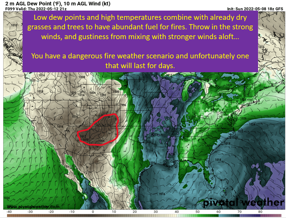
Obviously it takes a spark to start an actual fire, but the temperatures play a big role in the evaporation of water within grasses and trees. I think about these scenarios more like a chemical engineer, specifically the water at the surface is in a vapor/liquid equilibrium. If you raise the temperature, you increase the evaporation rate all else being equal. The evaporation from plants isn’t going to change the dew points at the surface. This isn’t a moist Iowa cornfield sweating, but already relatively dry grasses and trees.
It does cause more of that precious moisture to leave the plants and make them easier to ignite.
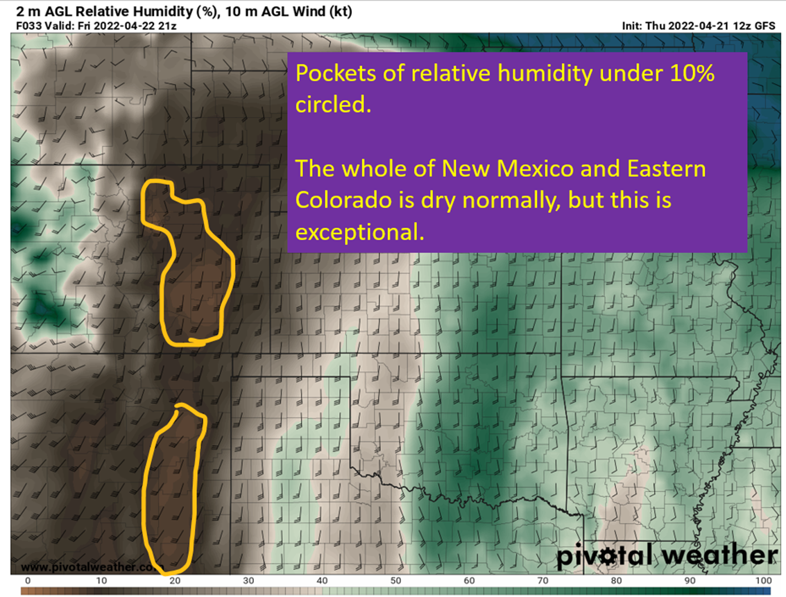
Extremely Low Relative Humidity Also Leads To Evaporation

Down here in the Southeast, the dew point best describes how humid it feels outside. When dealing with fire weather, relative humidity is more important when considering evaporation rates of the grasses and trees.
Air can only hold so much water vapor, with the amount it can hold depending on the temperature. The lower the relative humidity, the more water vapor it can accept. More importantly, the greater the driving force for water to leave plants as water vapor. So we get more evaporation going on with the warm and dry airmass to suck up more moisture from the potential fuels and making them even easier to burn.
Strong Winds Drive Fires and Enhance Evaporation

The combination of a quickly strengthening low pressure to the north and daytime heating allowing for mixing with the mid levels to have strong gusts come down to the surface will cause strong winds and gusts in the 60 – 70 mph range by tomorrow afternoon in eastern Colorado. This will make fire behavior unpredictable and fires will spread extremely fast in this environment. So fires would be able to burn quickly in extremely dry fuels and the wind will let them grow rapidly and unpredictably.
Suboptimal.
The High Winds Also Increase Evaporation
A convection oven cooks food faster by moving the hot air around and disrupting the boundary layer around the food, making heat transfer more efficient. It turns out, the same idea holds when discussing evaporation from plants. Blowing hot and dry air over the plants will increase the evaporation rate as compared to having a still layer of dry and hot air over them. The movement of air will steepen the gradient between the interface of the plant/air where it would be relatively more humid due to the evaporation happening right there and the environmental flow which is obviously very dry. This increases the heat and mass transfer, which is what evaporation from the plants is.
The Drought Has Fuels Unusually Dry For April

The years long drought in the American West continues, with exceptional drought conditions extending into the southern high plains of New Mexico and into the Texas Panhandle. While not as severe in eastern Colorado, the drought still means already dry fuels are present. Couple that with the blow-dryer tomorrow afternoon, and that’s an abundant source of fuel for fires.
Unfortunately, I doubt this is the last fire weather post of the year with the drought only expected to worsen this summer.
tl;dr version

Oh look, the SPC is also concerned with isolated dry thunderstorms providing a spark tomorrow.
The combination of high winds, extremely dry air, and hot temperatures will combine to create an extreme fire risk tomorrow across central and NE New Mexico and eastern Colorado (including Denver). Storm chasers along the dryline pushing east will be looking for thunderstorms tomorrow, but the source region of that dryline will be watching for fast moving wildfires. It doesn’t help that the drought out west continues, leaving unusually dry fuels to have even more moisture pulled out of them.
Fire weather is severe weather y’all.
Tomorrow I’ll have a Severe 101 up with the second part of the hodograph series. This weekend, I’m going to take a break from the weather and tell y’all about the great food and music at French Quarter fest. Enjoy the nice weather in the deep south everyone!