The Humidity Returns For A Busy Weekend In Louisiana
The Rundown
Humidity returns by the weekend, with rain chances increasing by Sunday.
Jazz Fest starts tomorrow in New Orleans, with the big acts going Friday through Sunday. Over to the west, Garth Brooks will be Callin’ Baton Rouge at a huge concert in Tiger Stadium. Keep west on I10, you’ve got the Festival International de Louisiane in Lafayette. It’s late spring, so I’m sure many other events will be going on along the Gulf Coast and into the deep south.
On Saturday, deep thunderstorms are unlikely with dry air aloft to sap any moisture that tries to get lifting along the Gulf Coast. There will be a few clouds to give a little break from the sun, but it’s going to be hot out there. Highs into the mid to upper 80s with dew points getting back to the upper 60s. Farther north into Mississippi and Alabama though, there will be chances of isolated to scattered showers.
On Sunday, low rain chances return to the Gulf Coast and widely scattered showers will be expected up in middle to north Alabama. It’ll once again be hot and muggy with the high 80s and dew points in the high 60s expected. Summer is coming. Bring the sunscreen and shorts with ya.

Saturday: Isolated Showers In Louisiana, Higher Rain Chances North and East
The Big Picture
There are going to be storms and rain up in the Middle Mississippi Valley as a large upper low migrates east during the day on Saturday. Up around Memphis, scattered storms seem likely by the afternoon. Farther south, there isn’t going to be a lot of forcing to get things moving upward. I see some upper divergence over the Gulf Coast by Saturday afternoon on the models, and a little bit of help at the 500 mb level. So I can’t rule out some isolated storms but the vast majority of locations should stay dry along the Gulf Coast.

Dry Air Aloft Is The Main Limiting Factor For Saturday Storms
A couple of things are going to be keeping the rain chances low. The main limitation is going to be some very dry air above the surface. This leads to evaporation and slamming any vertical motion back down, though could get some gusty winds from rain showers that do end up surviving this. Secondly is the humidity might not really come back strong until the evening. On top of that, there’s not likely to be anything at the surface to be a focus for storms to go up from.
So isolated, with chances increasing farther to the north. There will be some pockets of moister air aloft over toward Alabama and Georgia it looks like, which would increase the rain potential over that way.

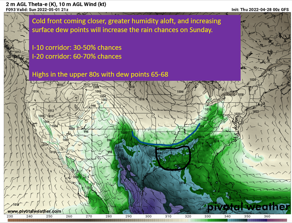
Sunday: Rain Chances Increasing And Humidity Continues To Rise
A cold front will be pushing toward the Southeast by Sunday and increase the rain chances from very isolated to scattered (30-50%) with the increasing surface convergence. The front isn’t actually going to make it to the coast though. Which means rain isn’t a certainty along I10 and chances will be higher toward I20 since it will at least be closer to the incoming front. Rain chances up around Alexandria, LA to Jackson, MS to Birmingham will be more like 60-70% Sunday afternoon. Down south in Lafayette, New Orleans, and Mobile it will be in that 30-50% range.
It’ll also be plenty warm with highs getting into the mid to upper 80s for all locations. Dew points will be increasing somewhat vs Saturday with numbers pushing 70 close to the coastline. So summer-lite conditions out there for the festivals come Sunday.
In other words, grab a poncho just in case but shouldn’t be a washout in Lafayette or New Orleans on Sunday.

tl;dr version
Humidity starts increasing on Friday and continues through Sunday. Saturday and Sunday will both be in the upper 80s with humidity getting higher on Saturday and getting a little muggy by Sunday. There will be some isolated rain chances on Saturday down near the coast and scattered chances around Memphis, Jackson, and Birmingham. Rain chances increase on Sunday, but should just be scattered along the I10 corridor and more widespread along I20 and farther north. Otherwise, expect a party cloudy day both days. So if you’re out and about, bring the sunscreen.
That’s all for today. Will be talking severe weather in the plains tomorrow.