It’s Gonna Be May: Multiple Rounds Of Severe Next Week
The Rundown
Yes, I know the pun is bad and overused. Sometimes you just have to lean into it.
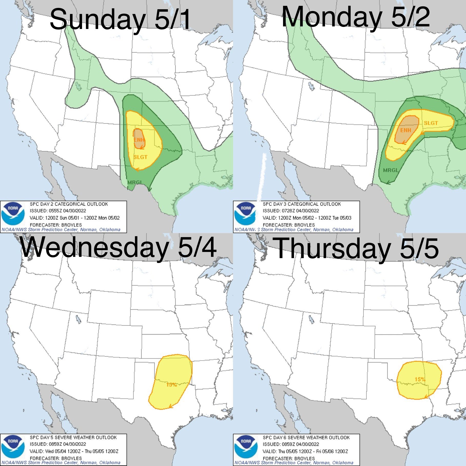
The good news, for us, is the severe weather threat shifts toward the Plains this time of year. The bad news is, there’s going to be severe weather in the Plains this coming week. Starting Sunday, multiple rounds of severe potential will be working across the middle of the country. Oklahoma gets all three work week rounds with potential on Monday, Wednesday, and Thursday. That Thursday one will bring Dallas, western Arkansas, and Shreveport into the mix as well.
Today I’m going to go big picture. Not going to focus on one day in particular just yet, but watching how the features are going to evolve over time. Also, remember that I’m going to be using a single model to depict what’s coming. That means I’m just looking at the general idea, ignoring details, and understand some things will change.
Jet Stream Evolution

When looking at the jet stream level, I’m looking for a few things. The first is simply where the strongest winds are. This is where the temperature gradient of the troposphere is at its greatest and good locations to start looking for the upper level features that help drive severe weather.
The second thing is areas where the winds split off in different directions. This is called difluence (not to be confused with divergence…which is something I’ve done plenty myself). These typically are areas of divergence, but don’t have to be. Anyway, there’s a little bit of that going on by Sunday and Monday looking toward NM and the panhandles of TX and OK. It’s subtle but there. By Wednesday there is an obvious pocket of it near the panhandles again where the southern and northern jet meet and then split. That area of split is a nice spot for low pressure to develop.
The next thing I’m looking for is actual divergence. This is when wind goes from an area of fast moving to slower moving. That is present over New Mexico and Oklahoma on Sunday and Monday respectively. Again by Wednesday, in the area of difluence and just ahead of the nose of the strongest jet stream winds. Those are areas that favor forcing for ascent.
Finally I’m looking for areas next to the strongest jet stream winds. Specifically I’m looking on the left side (if you imagine an axis going through the middle of the strongest winds) near where the strongest winds start (east side). The left exit region. I’ll do the same thing on the right side of that axis, looking at the area the winds start dropping off (west side). That’s the right entrance.
What Did I See?
To sum it up, there’s a decent bit of divergence coming with the streak into New Mexico on Sunday. You can see a low pressure system form and strengthen in that general area. This means we’ll be looking there on Sunday for severe potential. Monday this region shifts east toward Oklahoma, and again, will be looking for severe weather there on Monday. This jet streak weakens by Tuesday but another system is about to come off the Rockies by then.
On Wednesday, we see a nice splitting of the jet streams and a pocket of divergence with it. A low tries to form roughly in the right entrance of the jet (it’s not always that easy to spot) along the Texas Panhandle but the best forcing for ascent ends up just ahead of the jet streak and you see a low pressure form there and move NE toward the Ohio Valley.
Next up, 500 mb level. Which, at least, has fewer little things to look for.
500 mb: Numerous Waves Cross The Country

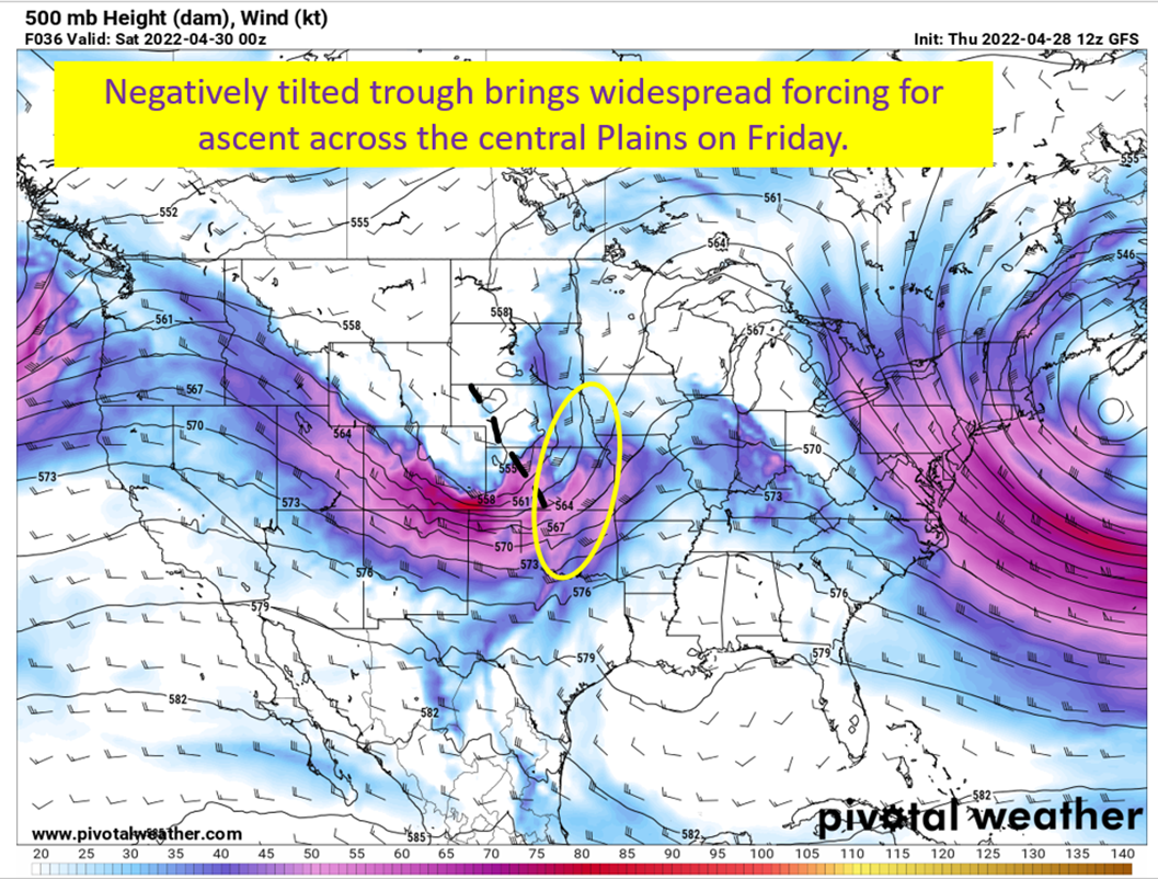
What I watch here are areas of cyclonic vorticity, which tend to promote vertical motion. Especially on the eastern flanks. Then, what’s going to be harder to see in a gif, is I’m checking the orientation of the troughs. Basically, when you get one tilted from NW to SE you have a negative tilt and those provide the best dynamics for severe weather. The last thing I’m looking for are where the strongest winds are, since that extra pop of wind will typically increase the shear and be supportive of supercells. You know, assuming it’s placed where lift is favored.
See I told you it wasn’t going to be as much this go round.
What Did I See?
A couple of potent shortwaves (little troughs) coming off the Rockies. The first is Sunday, supporting the severe weather threat in New Mexico and the panhandles. It eventually takes on a bit of a negative tilt by Monday, which suggests a potentially very active day in Oklahoma or at least the potential for very strong tornadoes. This first system gets sheared out as it moves to the east and ends up not being of significant concern for the Rust Belt.
The second system is following right behind, getting into the Plains by Wednesday. This is coupled with the jet stream diffluence and divergence mentioned earlier in the post, and brings another round of severe chances to the Plains and eventually into eastern Oklahoma, western Arkansas, northern Texas, and even Shreveport by Thursday. Just going to watch how this evolves for a couple of days before I go into details on this one.
Next up, the 850 mb level. Looking for high winds and winds out of the south.
Looking For Low Level Jets

I found me one! I’m going to hold off on looking for low level jet placement on the Wed/Thurs event because placement of low pressure will have a lot to do with where a jet sets up. So we have a strong low level jet for Oklahoma and Kansas come Monday night, which is lined up with where the forcing from the shortwave and upper level support will be. No surprise, the SPC already has the area under an enhanced risk three days out. There will be good low level winds in New Mexico and the Texas Panhandle tomorrow afternoon as well, but the ground level is above 850 mb and won’t show up on the model.
Also, note in the above image how the wind is pulling off the Gulf of Mexico. That will transport higher dew point air up into Texas/Oklahoma/Kansas/Arkansas by Monday evening. That helps build up the instability ahead of the dryline that will be in place.
Finally, let’s take a look at how the dew points at the surface evolve from Sunday evening until Thursday evening.
Dew Point Surges Into The Plains

The moisture surges up to meet the low pressure systems. You can actually see the dryline form a couple of those days. It is, weirdly, where the high dew points and low dew points meet over the middle of the country. These surges of warm moist air increase the potential for convection and the dryline gives a focus for some confluence/convergence at the surface. The first good surge is on Monday, though 55+ dews in the Texas Panhandle is moist for them.
The cold front following the Monday low clears them back to the south on Tuesday but once again you see them surge up by Wednesday. This moist air remains a little farther east for the Thursday severe potential before a cold front swings down and brings a round of heavy rain for the Southeast on Friday.
tl;dr version

There are multiple rounds of severe weather coming this week, and you can see them coming watching the upper levels and dew points evolve. The jet stream provides lift from the divergence of the upper level winds and positioning near the jet. At the 500 mb level, the shear and lift provided from the shortwaves moving across the country also go to create an environment favorable for severe thunderstorms. Then the low level winds respond, increasing the low level shear and the tornado potential. Finally, you need buoyancy and the surge of dew points at the surface, in part, create this.
That’s what I’m watching in the weather for the upcoming work week. Thanks for checking in.
Updates may be a bit slow this week, as I have jury duty to attend to.