
Discussing The Hurricane That Isn’t Happening, Again
I already had a post written and ready to go for today. It is about the pattern change upcoming that will bring relief from the heat to the Southeast and start severe weather potential back up for the Plains. That is not what I’m going to be talking about today. Instead, the GFS decided to bring the hurricane back last night.
Which I still don’t think makes a whole lot of sense.
The thing is, I know it gets traffic on social media and I see questions about it on message boards. This means I need to dig in deep to the GFS and the Euro. I’m going to explain why the GFS keeps spinning up a hurricane, why I don’t think it makes much sense, and show you what the ensembles are showing. So today, May 17th, I’m talking the tropics again.
Get ready y’all, this is going to be a long one. Below are the links to specific sections, if you want to skip to a particular section.
- Upper Levels Pull Gyre North
- Euro and GFS Differ On Shear
- Dry Air Will Hinder Development
- Ensembles Aren’t Buying It
The Central American Gyre – First Point Of Uncertainty

The Central American Gyre (CAG for the rest of the post) is starting to spin today and will continue through the weekend, at the very least. An early tropical wave is going to get caught up in it. There is also a Convectively Coupled Kelvin Wave (CCKW) coming through the region into the weekend that will enhance rising air. All of this together supports the idea of a tropical system forming. The first question is where?
Consider how large that rotation is. There is vorticity (spin) on both sides of Costa Rica here, which means there is potential for something to form on the Pacific side or the Atlantic side. It could also just try to form over land and never amount to anything.

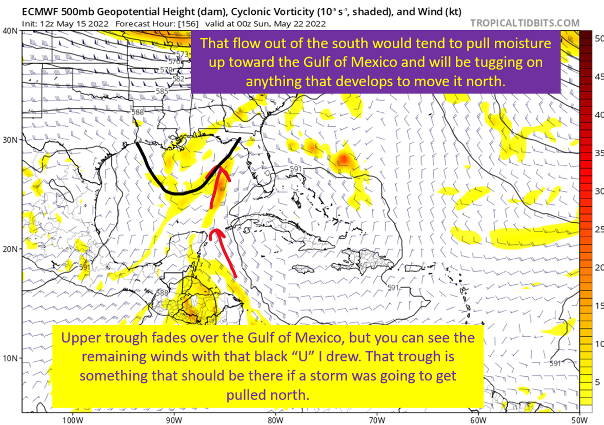
Upper Trough Pulls Gyre North By Weekend
There is going to be a little bit of an upper trough cross the Gulf of Mexico this weekend. It is going to pull on the gyre and bring it north toward the Yucatan. I do also want to note that the GFS was originally trying to spin a storm up sooner and move it north sooner, with this latest set of fantasycanes being later in development. This is a red flag for me, having the model push the storm back in time.
That aside, the European and GFS both agree on this general evolution. Tugging the moisture north and potentially having something form closer to the Yucatan. The European yesterday even spun up a system in the Bay of Campeche, and then buried back into Mexico. The GFS, on the other hand, has been forming a tropical system on the east side of the Yucatan.
The point is, around the Yucatan seems to be the more likely time and location for formation at this time.

Euro and GFS Have Huge Differences At The Upper Levels
The European has the subtropical jet still active over the Gulf of Mexico. In terms of the coming upper level pattern over North America, this evolution makes the most sense to me. This also means there would be abundant shear over the southern Gulf of Mexico. It would push the convection to the east of the center, let dry air work in from the west, and keep a potential system weak.

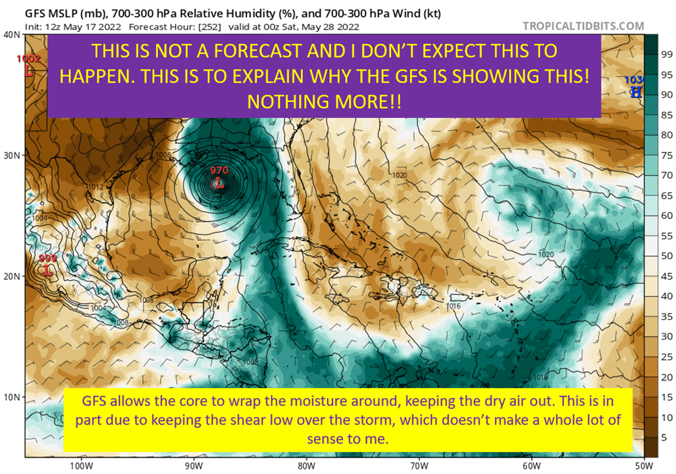
The GFS Has Other Ideas. Upper Level High Helps The Storm Instead.
The GFS has something that looks more like late September than May. It tucks the storm under a broad anticyclone at the jet stream level. So instead of the strong winds of the subtropical jet the Euro has, it has benign shear conditions. In addition, the orientation would allow for the storm to have an outflow channel. This allows a storm to strengthen by letting it pull more air in at the surface and vent it out aloft. That’s part of the strengthening story on the GFS.
I’m quite skeptical of this evolution.

Dry Air Will Be A Hinderance
Whatever ends up happening, even these dubious GFS solutions, there will be a battle with a potential storm and dry air to the west. Flow over the continental US will be from the west, and it’s awfully dry out that direction. This will bring rounds of dry air into the western half of the Gulf of Mexico. On the east side of the Gulf of Mexico, there will be a plume of moisture being picked up from the south. This suggests, to me, we would see a lopsided tropical storm. That is considering the shear and the placement of dry air. Below I’m going to show you the GFS and it’s forecast of mid-level humidity on Friday of next week.
DON’T take the pressure there to be true. I really think it is too strong and I don’t want people getting too worried about it at this point.

So Why The Heck Does The GFS Strengthen This So Much?
The GFS solutions over the past day have generally had the same idea. Storm would form early next week, as compared to this weekend on the previous runs. As it does this, it gets an upper level anticyclone over it and this reduces shear and also allows the storm to ventilate better. Next, it allows the storm to wrap that moisture all the way around the core and shut the dry air out. All of this together is why the GFS storms end up maximizing the strength possible over the Gulf in May.
In addition to all of that, it still strengthens extremely quickly after formation. Dropping about 20 mb of pressure in a day and making a core that would survive land interaction over the Yucatan mostly in tact. That’s part of it’s convective biases, and isn’t realistic in the slightest. It’s forming off a gyre, organization should be a lot slower.
Basically, the GFS keeps bringing all the right ingredients together at the exact right time but part of that is due to how the model handles the amount of heat a low is able to extract. It happens too quickly, and works together to make these conditions unusually conducive on these GFS depictions.

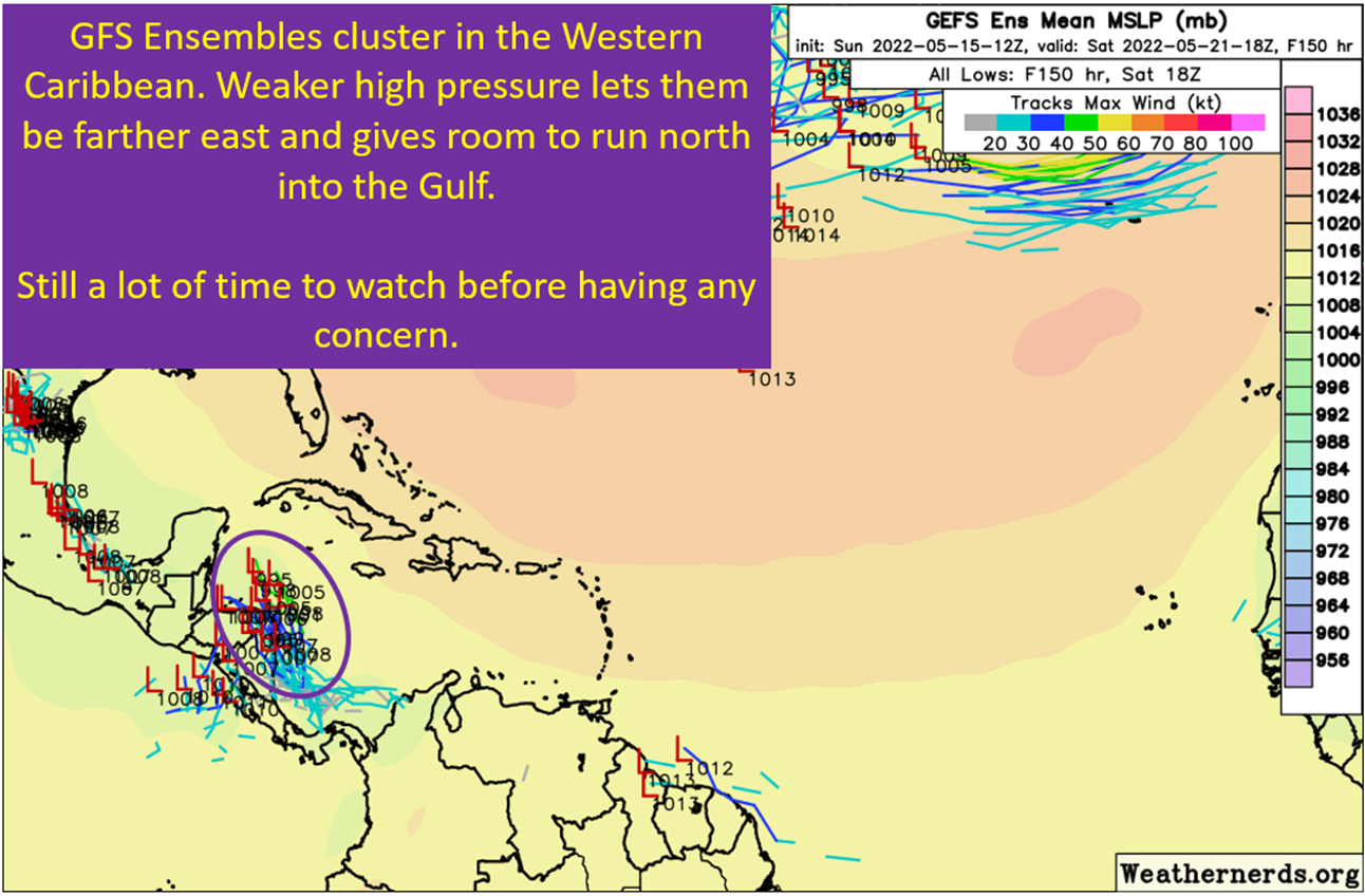
Even The GFS Ensembles Aren’t On Board
Since the GFS started producing a May hurricane last week, there has been some ensemble support for the idea. Now, there really isn’t. Not a single member on the 12z run on 5/17 gets a storm as strong as the operational GFS shows. In addition, there is only one member with the same timing as the current GFS. The rest of the low tracks get moving much earlier, and stay in that 1000-990 mb range. In fact, fewer members have anything in the Gulf today as compared to last night.
The European ensembles are even less bullish, with only a few members producing a tropical cyclone in the Atlantic side at all! Plus none get near the strength of the GFS operational runs.
The GFS operational is all alone on this one.

tl;dr version
The GFS is all on it’s own with a hurricane coming to the northern Gulf Coast. It does this because it strengthens the storm too fast, places it under unrealistically benign shear conditions, and allows it to wrap moisture around the core to fight off the dry air to its west. None of this is likely, as a storm that could form should take a while to tighten up. This will let the shear and dry air keep getting in there, and again, I expect the shear to be stronger than the GFS shows. Additionally, the GFS slowing down the timing makes me even more dubious of this signal.
Getting a weak tropical storm off this set up? Yeah, that’s reasonable. It would be sheared with the weather all on the east side and winds would remain likely near minimum tropical storm strength. A hurricane? It just doesn’t make sense.
Related Posts

Hurricane Season 2023 Preview: El Nino Returns
98-L: The Model Madness Continues
Y’all Need To Pay Attention To The Next Wave
Expecting Danielle By The Weekend. Otherwise, Shear and Dry Air Dominate.
Watching The Caribbean For Tropical Trouble
The “Ring of Fire” Continues and Weekly Tropical Update
Summer Of The “Death” Ridge: Hot but Helpful In Terms Of Tropics
In A Huge *NOT* Surprise, The May Hurricane Isn’t Happening
Third Week In May: The Big Weather Stories
