The Tornado That Wasn’t A Tornado
On April 15th 2022, a tornado emergency was issued for a supercell in northern Arkansas. This is the most serious of tornado warnings, reserved for damaging tornadoes. The problem? There wasn’t actually a tornado. In this post I’m going over what happened. I’m going to look back at the radar and discuss how the distance this storm was from any radar would have played some role. In addition, I’m going to discuss the false spotter reports that contributed to the tornado emergency being issued as well.
One last note: this is not meant to be critical of the radar and warning coordinator at NWS Little Rock. I’ve never been on the radar in a situation to put out warnings. It is fast moving, and especially challenging when not getting near the ground radar data. It is even harder when you are getting false storm reports. This is an exercise to figure out what happened, not to caste blame at highly trained and hard working people!
Radar Was Getting Data From 10,000 Feet
There are what are known as “radar holes”. These are areas of the country where there is not a radar close enough to get the lowest levels of storms in a location. In this case, the storm spent a significant amount of time in an area where the lowest cut was 10,000 feet above the ground. This means looking at the mid-levels when a tornado would be happening closer to the ground.

So the radar data wasn’t ideal. I’m going to be pulling from both the Little Rock (KLZK) and Memphis (KNQA) radars to try and put the pieces together but both sites will still be showing data at least a mile off the ground.
Atmospheric Conditions
Before getting into the radar, it is necessary to look back at the atmospheric conditions on evening of 4/15. This is context the decision makers at NWS Little Rock would be considering when putting out warnings. The first piece I’m going to look at is a surface analysis from the Weather Prediction Center at 7 pm central on 4/15. There is a warm front along the Missouri/Arkansas line. Warm fronts increase the tornado potential and this storm was riding right along the boundary.

The next thing I’m going to show you is the observed sounding from NWS Little Rock on the evening of 4/15. The main takeaways are:
- A shear profile supportive of supercells and good enough low level shear for tornadoes.
- Strong upper level shear along with instability in the hail growth region. No surprise this storm was a prolific hail producer.
- Instability doesn’t jump off the page, and is 0 in the lowest 3km of the atmosphere. That could have been better along the front though.
- I can see how tornadoes were a concern in this environment.

My Radar Set-Up
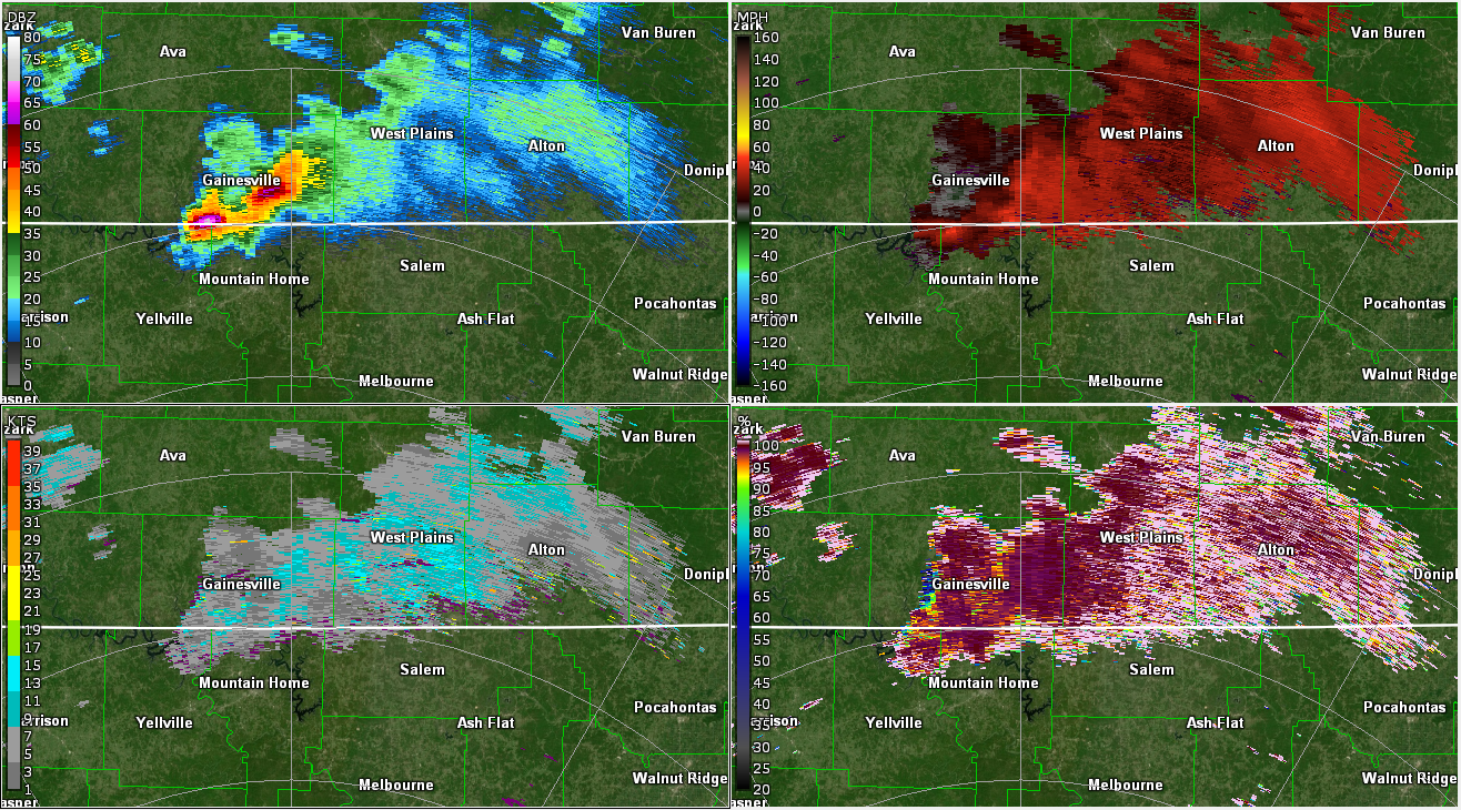
I’m going to be using the Little Rock radar for this section, since it was the closest to the storm. I’m going to have four panels up for each image with a different radar product in each. Starting in the top-left and going clockwise, the products are:
- Base Reflectivity: What you think of as a radar image. Shows intensity of precipitation based on how much radar beam bounces back to the receiver. More bounceback, hitting more or bigger stuff.
- Base Velocity: Shows wind speeds, with red colors moving away from the radar and green colors moving toward the radar. Rotation is noted when you get wind blowing toward and away from the radar in close proximity. Tornadoes will typically have high winds in each direction.
- Correlation Coefficient: This product shows you how similar in shape the things the radar are hitting in that area are. Red colors are very similar, which you expect with rain. Blue colors are very dissimilar, which can happen with hail but also when debris is lofted into the air by a tornado.
- Spectrum Width: This is looking for turbulence. Strong updrafts are turbulent and you’d expect this to light up in the proximity of a tornado or at least an updraft at height capable of producing a tornado.
I will at times pull up Differential Reflectivity in the Spectrum Width spot. This product compares horizontal and vertical size. It is useful for seeing hail (since the vertical and horizontal will be similar) and debris which would also generally have low values on this product.

Early Stages With A Right Turn
The storm was riding along the Missouri/Arkansas border and then took a more ESE trajectory, which is something we look for with developing supercells. It caught a tornado warning soon after the above image and had a Tornado Emergency issued around the time it got to Salem, AR. That’s the next radar image I’m going to show you, when it got to Salem.

Just looking at this, I would have had serious doubts about a tornado on the ground but there are some things that complicate the picture. The first is the correlation coefficient is hitting enough hail to not be all that helpful. It probably is hail but I could see where you might have questions, especially when a trained spotter is reporting a tornado in progress. There is a little bit of rotation there, and we’re looking around 11,000 feet in the air. You know the low levels are supportive enough for a tornado, and the storm obviously has a good updraft going. You have some turbulence near the location of some rotation.
I also have to remind myself and my readers, I’m not a radar expert and have never been on the radar making these decisions.
Storm Continues But Still Lacks Strong Radar Appearance
Next up is when the storm was approaching Cherokee Village, where the presentation on radar is even more dubious in my opinion. A tornado warning, based on some rotation being present leading up to the Cherokee Village approach and some spotters reporting a tornado, is hardly unreasonable. My question is why the highest level of warning with a Tornado Emergency? In the following image, it had crossed through a little town, so if a strong tornado was on the ground there should have been a more clear debris signature. This is still up around 10,000 feet, but tornadoes get debris up that high and up above 20,000 feet with violent tornadoes.
The other problem is where debris might be isn’t located with the turbulence and possible rotation. It is nice to have the benefit of time to examine these images though and to already know there was not a tornado ongoing at this point. A little different than being in the hot seat making decisions, knowing that if you go with a lesser warning and the spotter report is right you could kill someone.

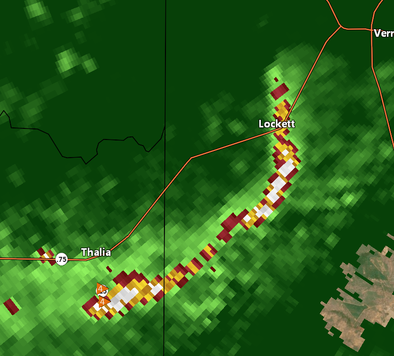
For the final frame I’m gong to show you, I’m switching radar sites over to Memphis since it would be closer at this point and will get a better look at the lower levels. By “lower levels” I mean around 7000 feet, but that’s much better than the 10,000+ we have been getting from Little Rock to this point. The presentation by this point has become of a high wind event with gigantic hail in the hail core. I assume the Tornado Emergency was kept on because it was heading into a higher population area (though that isn’t part of the decision making criteria for a tornado emergency).
Walnut Ridge: No Tornado but Wind Driven Baseball+ Sized Hail
At this point, it has become a strong wind event on radar with not much on velocity to suggest a tornado. Of course, that does not mean threats to life and property were over though. The storm had a history of producing softball sized hail and the strong wind signature was partially in the hail core. I don’t know about you, but I don’t want to catch a softball sized chunk of ice flying at 60 mph.

Why Issue A Tornado Emergency? False Spotter Report
This is where it gets frustrating. A trained spotter on the spotter network made false reports of a wedge tornado. Way to make a tough job that much harder with bad information and potentially have people not respect a Tornado Emergency warning in the future. On top of that you have a storm that would have produced a rain wrapped tornado and it was nightfall. Those are difficult for the best to spot, and the storm was producing non-rotating funnel looking clouds called “scuds”. These, for the general public, are very easy to confuse for a tornado and more so when they are looking for a tornado. This just increases the flow of dubious storm reports, but at least those were without malice.
It is better to have a false alarm than to have a non-warned strong tornado. I do understand erring on the side of caution in this case, but I also suspect there was a lot of debate on the floor at NWS Little Rock and skepticism from the SPC and others. You’d typically see a mesoscale discussion from the SPC with a large tornado on the ground, and none came. I know the meteorologists at the NWS are at the very least as proficient at reading a radar as I am.
I think the lesson here would be to trust the radar, and dial this back to a general tornado warning.
Finally, I’ve got a thread from a meteorologist from the NWS in Mobile who posted detailed thoughts concerning this case.
That’s all for this. I’m taking this as something to learn for my own sake, and to share some of the difficulties meteorologists face in situations like that.
I’ll be back in the next day or two to preview a quiet weather week ongoing. Which is good after all the severe weather. Downside? It’s going to start heating up.

